Ongoing snow showers to bring additional accumulation through Friday
Winter weather advisories remain in effect for parts of Southcentral through 10 a.m. Friday
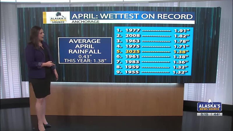
ANCHORAGE, Alaska (KTUU) - Spring is on track to potentially tie or dump the same amount of snow that fell through fall and winter.
Beginning March 1, Anchorage has received 22 inches of snow. Only 9.5 inches of snow is needed the rest of this season for this spring to go down as snowier than fall and winter combined. This has only occurred three other times in record history, with those years being the spring of 1976, 1984 and 1994.
SOUTHCENTRAL:
Winter weather advisories remain in effect for the following locations until 10 a.m. Friday.
- Anchorage
- Eagle River
- Interior Kenai Peninsula
- Western Prince William Sound/Turnagain Pass
Several inches of snow is to be expected from today into Friday, with the hardest hit areas seeing the potential for up to 8+ inches of snow accumulation. Those locations will likely be areas of the Interior Kenai, and through Turnagain Pass. The rest of Southcentral that remains under the advisories, 2 to 6 inches of snow accumulation looks likely, with higher amounts. The Anchorage and Eagle River Hillsides will have the potential for slightly higher amounts, although most areas of higher elevations will see near 6 inches of snowfall.
We’ll see a few dry breaks throughout the day, but in general expect Thursday to be a snowy one, with highs likely remaining in the 30s. Any snow we see will gradual taper off into Friday, with any accumulating snow likely to melt into the weekend and through early next week.
While this week has been on the cooler side, we’ll see the return to warmer weather into the weekend and next week. It’s likely highs could warm nearly 10 degrees in some spots, as we see the mid 40s making a comeback. While we do see a transition to rain showers for next week, some pockets of light wintry mix will still be present in locations will temperatures remain cooler in the night and early morning.
SOUTHEAST:
Ample rain has fallen across Southeast this week, with many areas having eclipsed 1 to 2 inches of rain. Higher amounts have fallen near Yakutat and through the southern inner channels. Like we’ve experienced most of this week, some dry time will be evident each and every day. The overall trend though continues to favor a wetter weather pattern for the panhandle. This will be good news for an areas that is still overcoming a rain and snowfall deficit that for some areas dates back to last year. While the wet weather remains, temperatures will still remain fairly mild. We’ll see daily highs topping out in the upper 40s and lower 50s.
INTERIOR:
Snow showers remain for areas of the Interior that are along the south facing slopes of the Brooks Range. These locations can expect to see several inches of snow between today and into Saturday, with highest amounts likely through Atigun Pass. The rest of the Interior will tap into some snow later today into Friday, with some light accumulation looking possible through the day tomorrow. As an upper level disturbance sweeps through the region, we’ll also see a brief return to highs in the low to mid 30s for Friday. As the disturbance moves through the Interior, we’ll see some gusty winds develop. The strongest winds look to be through the Alaska Range passes, which will likely last through the weekend. These strong southerly winds will lead to highs climbing into the 40s and possibly even 50s through early next week.
SLOPE/WESTERN ALASKA:
On and off light snow showers remain for areas north of the Brooks Range, where 1 to 2 inches looks possible for the immediate coast. Through the Brooks Range and areas along the slopes, higher amounts are to be expected. Thankfully, winds don’t look to be much of a concern as the week draws to a close, with most winds remaining lower than 20 mph. While temperatures have been a bit on the colder side this week, we will see temperatures warming into the 10s and 20s through the weekend.
While the rest of the state has at least seen mild temperatures, areas out west remain fairly chilly. These below normal conditions will persist to close out the week, although we will see a slow warming trend. While things remain fairly quiet, we’ll still see the potential for some light snow for coastal areas of Southwest Alaska. This comes as weak low in the Central Bering Sea will move to the southeast. This will bring increasing snow chances and gusty winds for the Yukon Delta and areas of the Kuskokwim Delta coast Friday into Saturday. Snow amounts will be on the light side, but still likely we could see 1 to 3 inches of snow accumulation.
ALEUTIANS:
Cold air remains in place across the Aleutians and north in the Bering Sea, with quieter weather the last few days. While we can’t rule out some areas of light snow into the evening for the Pribilof Islands, most locations remain on the dry side today. A low will skirt just south of the Aleutians tomorrow, before lifting north into the weekend. This will lead to increased rain and snow for areas of Bristol Bay and the Alaska Peninsula through the weekend. Temperatures will largely depend on what type of precipitation will fall, but colder weather looks to remain for areas of Bristol Bay. This is where we’ll likely see the best chance for snow to start out, before transitioning into rain. It’s shaping up that areas of Southwest Alaska and the Aleutians could see a return to more active weather into next week.
AVALANCHE WEATHER:
Turnagain Pass: Considerable avalanche danger above 1000 feet. Avalanches failing within new and windblown snow are likely.
Summit Lake: Moderate avalanche danger at all elevations, with recent snow adding weight to an already weak layer buried a foot deep. A small avalanche could be trigger, with the possibility of a much larger avalanche failing deeper in the snowpack.
Seward/Lost Lake: Considerable avalanche danger above 1000 feet. Avalanches failing within new and windblown snow are likely.
Valdez: Considerable avalanche danger at all elevations. Different avalanche problems exist at differing elevations. Both natural, and human triggered avalanches will be likely.
OUTLOOK AHEAD:
Active weather looks to return to Southwest Alaska and the Aleutians starting this week and into next week. Due to the nature of our temperatures, snow and rain chances look to remain in the forecast. It’s likely all snow will stick around for many areas west of Bristol Bay, with locations east of that seeing more in the way of rain and breezy conditions. We’ll also see rain along the coast remaining in the forecast, with a chance we could see some pockets of light snow or wintry mix as colder air moves in aloft. We’ll want to watch the overall forecast, as wet weather does remain with us for much of the southern coastline.
Watch Alaska’s Weather Source live 24/7. Get access to live radar, satellite, weather cameras, current conditions and the latest weather forecast. Also available through the Alaska’s News Source streaming app available on Apple TV, Roku, and Amazon Fire TV.
See a spelling or grammar error? Report it to web@ktuu.com
Copyright 2025 KTUU. All rights reserved.